Emergency vehicle locator
US20170270792A1
2017-09-21
15/462,908
2017-03-19
✅ Patent granted
US 10,687,189 B2
2020-06-16
-
-
Tanmay K Shah
2037-03-19
Abstract:
A system for simultaneously displaying the locations of all nearby emergency vehicles onto the same moving map as the current location of another vehicle is described. Each emergency vehicle receives location data from a GPS receiver and broadcasts the location data using a Bluetooth or other transmitter. Other vehicles receive location data corresponding to their own locations using their own GPS receivers and each displays their own location onto their own moving map display in the usual manner. Additionally, the other vehicles also have Bluetooth or other receivers which receive the local broadcasts containing emergency vehicle locations and display the locations of all emergency vehicles simultaneously with their own location. The operator of the vehicle benefits by knowing the relative locations of the emergency vehicles when they cannot be seen. Some emergency vehicle operators may optionally choose to not broadcast their location data under certain circumstances.
Applicant:
Interested in similar patents?
Get notified when new applications in this technology area are published.
Classification:
G01S5/0072 » CPC further
Position-fixing by co-ordinating two or more direction or position line determinations; Position-fixing by co-ordinating two or more distance determinations; Transmission of position information to remote stations Transmission between mobile stations, e.g. anti-collision systems
G01C21/36 IPC
Navigation; Navigational instruments not provided for in groups - specially adapted for navigation in a road network; Route searching; Route guidance Input/output arrangements for on-board computers
G01C21/3626 » CPC further
Navigation; Navigational instruments not provided for in groups - specially adapted for navigation in a road network; Route searching; Route guidance; Input/output arrangements for on-board computers Details of the output of route guidance instructions
G01S19/13 » CPC further
Satellite radio beacon positioning systems; Determining position, velocity or attitude using signals transmitted by such systems; Satellite radio beacon positioning systems transmitting time-stamped messages, e.g. GPS [Global Positioning System], GLONASS [Global Orbiting Navigation Satellite System] or GALILEO Receivers
G08G1/137 » CPC main
Traffic control systems for road vehicles indicating the position of vehicles, e.g. scheduled vehicles; Managing passenger vehicles circulating according to a fixed timetable, e.g. buses, trains, trams within the vehicle ; Indicators inside the vehicles or at stops the indicator being in the form of a map
H04W4/00 IPC
Services specially adapted for wireless communication networks; Facilities therefor
G01C21/3667 » CPC further
Navigation; Navigational instruments not provided for in groups - specially adapted for navigation in a road network; Route searching; Route guidance; Input/output arrangements for on-board computers Display of a road map
G01C21/3697 » CPC further
Navigation; Navigational instruments not provided for in groups - specially adapted for navigation in a road network; Route searching; Route guidance; Input/output arrangements for on-board computers Output of additional, non-guidance related information, e.g. low fuel level
G01S19/17 » CPC further
Satellite radio beacon positioning systems; Determining position, velocity or attitude using signals transmitted by such systems; Satellite radio beacon positioning systems transmitting time-stamped messages, e.g. GPS [Global Positioning System], GLONASS [Global Orbiting Navigation Satellite System] or GALILEO; Receivers specially adapted for specific applications Emergency applications
G08G1/20 » CPC further
Traffic control systems for road vehicles Monitoring the location of vehicles belonging to a group, e.g. fleet of vehicles, countable or determined number of vehicles
H04W4/029 » CPC further
Services specially adapted for wireless communication networks; Facilities therefor; Services making use of location information Location-based management or tracking services
H04W4/026 » CPC further
Services specially adapted for wireless communication networks; Facilities therefor; Services making use of location information using location based information parameters using orientation information, e.g. compass
G08G1/00 IPC
Traffic control systems for road vehicles
H04W4/80 » CPC main
Services specially adapted for wireless communication networks; Facilities therefor Services using short range communication, e.g. near-field communication [NFC], radio-frequency identification [RFID] or low energy communication
H04W4/46 » CPC further
Services specially adapted for wireless communication networks; Facilities therefor; Services specially adapted for particular environments, situations or purposes for vehicles, e.g. vehicle-to-pedestrians [V2P] for vehicle-to-vehicle communication [V2V]
G08G1/0965 » CPC further
Traffic control systems for road vehicles; Arrangements for giving variable traffic instructions having an indicator mounted inside the vehicle, e.g. giving voice messages responding to signals from another vehicle, e.g. emergency vehicle
G01S5/00 IPC
Position-fixing by co-ordinating two or more direction or position line determinations; Position-fixing by co-ordinating two or more distance determinations
G01S19/14 » CPC further
Satellite radio beacon positioning systems; Determining position, velocity or attitude using signals transmitted by such systems; Satellite radio beacon positioning systems transmitting time-stamped messages, e.g. GPS [Global Positioning System], GLONASS [Global Orbiting Navigation Satellite System] or GALILEO; Receivers specially adapted for specific applications
H04W4/02 IPC
Services specially adapted for wireless communication networks; Facilities therefor Services making use of location information
Description
CROSS-REFERENCE TO RELATED APPLICATIONS
Not Applicable
STATEMENT REGARDING FEDERALLY SPONSORED RESEARCH OR DEVELOPMENT
Not Applicable
REFERENCE TO SEQUENCE LISTING, A TABLE, OR A COMPUTER PROGRAM LISTING COMPACT DISK APPENDIX
Not Applicable
BACKGROUND OF THE INVENTION
The present invention relates to displaying the location of nearby emergency vehicles on GPS map displays in vehicles to improve the situational awareness of drivers.
Drivers of vehicles often hear emergency vehicles but cannot determine their locations in relation to their own vehicle. Therefore drivers cannot immediately determine the best course of action for avoiding the path of approaching emergency vehicles. This can create a delay or safety hazard for both vehicles and for drivers and passengers of nearby vehicles. Resulting confusion and uncertainty also leads to less efficient traffic flow when emergency vehicles are heard by a driver but not yet seen by the driver.
Most drivers already have access to their physical location based on GPS technology. Drivers of vehicles with built-in GPS receivers and drivers with mobile phone or other mobile based GPS receivers can see the locations of their vehicles on their moving map displays but they cannot see the locations of emergency vehicles on the same display, even when their presence is known because of their audible sirens and flashing lights.
What is needed to improve traffic flow and safety is a low cost vehicle system to simultaneously display the locations of emergency vehicles onto the same moving map display that shows the location of their vehicle. More specifically, there is a need for a moving map display device showing the location of the driver's vehicle and the relative locations of emergency vehicles operating nearby. The existence of such a system would improve safety and traffic flow efficiency.
BRIEF SUMMARY OF THE INVENTION
A low-cost, GPS-based system for simultaneously displaying the location of one's vehicle and nearby emergency vehicles on a moving map display is described herein. This system is designed to be low enough in cost and highly reliable, making it deployable in large numbers in vehicles.
In one embodiment an emergency vehicle is equipped with a GPS receiver for determining the emergency vehicle's current location, a Bluetooth transmitting beacon for optionally broadcasting the emergency vehicle's location wherein the optional broadcast contains the current location data received from the emergency vehicle's GPS receiver after a communications means transfers the emergency vehicle's location data from the GPS receiver to the Bluetooth beacon. The GPS receiver, communications means, and Bluetooth beacon could all be housed in a single device or could be located in separate, connected devices.
Another vehicle is equipped with a GPS receiver for determining the vehicle's current location, a Bluetooth receiver for receiving broadcasts from Bluetooth beacons of nearby emergency vehicles containing the location information for those vehicles, a moving map display and a communications means for communicating the location information from both the GPS receiver and the received Bluetooth broadcasts from emergency vehicles for display of all vehicles on the same moving map. The GPS receiver, Bluetooth receiver, moving map display, and communications means could all be housed in a single device or could be located in separate, connected devices.
In another embodiment, a smartphone or smartwatch is equipped with a GPS receiver for determining one's current location, a Bluetooth receiver for receiving broadcasts from nearby emergency vehicles containing the location information for those vehicles, a moving map display and communications means for communicating the location information from both the GPS receiver and the Bluetooth broadcasts for display of both on a moving map.
Another embodiment is an asset tracking system for monitoring the locations of assets or fleet vehicles. A cellular phone network, satellite communications system, or other long range communications means is used in place of the shorter range Bluetooth transmitter/receiver of the emergency vehicle embodiments.
Other embodiments are contemplated in which the specific hardware configurations are chosen based on the specific application requirements and cost considerations.
BRIEF DESCRIPTION OF THE DRAWINGS
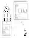
FIG. 1 shows a system for broadcasting the GPS based location data of an emergency vehicle to Bluetooth receivers within the associated Bluetooth receiving range.
FIG. 2 is an illustrative example showing the simultaneous display of a vehicle's current location along with the location of a nearby emergency vehicle on the same moving map display used for vehicle navigation.
DETAILED DESCRIPTION OF THE INVENTION
An exemplary embodiment of the invention is shown in FIG. 1. An emergency vehicle 50, e.g. a fire truck, an ambulance, or a police car has an on-board Location Broadcasting System (LBS) 60 comprised of a Global Positioning System (GPS) receiver 51, a Bluetooth beacon 53, and a communication means 52. The GPS receiver 51 receives broadcasts from the GPS constellation 54 satellites in the normal manner for this well-known technology and determines the geo-location of the host emergency vehicle 50.
The communication means 52 transfers the location data from the GPS receiver 51 to the Bluetooth beacon 53. The Bluetooth beacon 53 broadcasts a radio signal containing identifying information about the type of its host emergency vehicle, e.g. fire truck, ambulance, or police car, and the location data from the GPS receiver 51 throughout the local geographic area.
An arbitrary vehicle 59 employs a Dual Location Receiving and Display System (DLRDS) 61. The DLRDS 61 is comprised of a second GPS receiver 56, a Bluetooth receiver 55, a second communication means 57, and a moving map display 58. The second GPS receiver 56 receives broadcasts from the GPS constellation 54 satellites in the normal manner for this well-known technology and determines the geo-location of the host vehicle 59. The Bluetooth receiver 55 receives broadcasts from all Bluetooth beacons installed on emergency vehicles in the local area, e.g. the Bluetooth beacon 53 on the emergency vehicle 50.
As stated above, said Bluetooth beacon 53 broadcast contains information about the type of emergency vehicle as well as the location of the emergency vehicle 50. The second communication means 57 communicates all received emergency vehicle type and location information for emergency vehicles in the local area and the host vehicle 59 location obtained from the GPS receiver 56 to the moving map display 58.
Referring to FIG. 2, the moving map display 58 simultaneously displays the location and type of the emergency vehicle 50 (FIG. 1) and location and types of any other emergency vehicles in the local area that are broadcasting their locations as well as the vehicle location indicator 4 associated with the host vehicle 59 (FIG. 1). FIG. 2 shows that in this exemplary embodiment, the vehicle 59 with an associated vehicle location indicator 4 is traveling on H Street as indicated by the current street indicator 7, it is 550 meters from its destination 11 as shown by the distance to destination indicator 6, and that an emergency vehicle 50 is located in front and to the right of the vehicle 59 at about its 1:30 o'clock position. Furthermore, the emergency vehicle 50, indicated on the moving map by the fire truck emergency vehicle location indicator 1, is 600 m in distance from the vehicle 59, as shown by the emergency vehicle distance indicator 3. The emergency vehicle 50 is moving in the direction shown on the moving map by the direction of emergency vehicle indicator 2.
The present invention may be embodied in other specific forms without departing from the spirit or essential characteristics thereof. The embodiments described are therefore to be considered in all respects as illustrative and not restrictive, the scope of the invention being indicated by the appended claims rather than by the foregoing description, and all changes which come within the meaning and range of equivalency of the claims are therefore intended to be embraced therein.
Claims
I claim:1. An emergency vehicle location system comprising:
A first global positioning system for determining said emergency vehicle's location;
A radio frequency transmitter for broadcasting said emergency vehicle's location;
A communications means for communicating said emergency vehicle's location to said radio frequency transmitter;
A second global positioning system for determining the location of a second vehicle;
A radio frequency receiver for receiving said broadcasting of said emergency vehicle's location;
A moving map display for displaying the locations of said emergency vehicle and said second vehicle;
A second communications means for communicating the location of said emergency vehicle to said moving map display.
2. An emergency vehicle location system according to claim 1 wherein said radio frequency transmitter transmits at least one additional parameter from a list of parameters characterizing said emergency vehicle and planned travel route.
3. An emergency vehicle location system according to claim 2 wherein said at least one additional parameter is the type of emergency vehicle and said moving map additionally displays said type of emergency vehicle.
4. An emergency vehicle location system according to claim 1 wherein the radio frequency transmitter is a Bluetooth transmitter and the radio frequency receiver is a Bluetooth receiver.
5. An emergency vehicle location system according to claim 1 wherein the radio frequency transmitter communicates with a cellular phone network and the radio frequency receiver communicates with a cellular phone network.
6. An emergency vehicle location system according to claim 3 wherein the radio frequency transmitter is a Bluetooth transmitter and the radio frequency receiver is a Bluetooth receiver.
7. An emergency vehicle location system according to claim 3 wherein the radio frequency transmitter communicates with a cellular phone network and the radio frequency receiver communicates with a cellular phone network.
8. An emergency vehicle location system according to claim 4 wherein the second global positioning system is installed on a smart phone.
9. An emergency vehicle location system according to claim 4 wherein the second global positioning system is a portable system.
Images & Drawings included:

Sources:
- United States Patent and Trademark Office - verify current appl. status at the USPTO↗
Similar patent applications:
- » 20250014458
SYSTEM AND METHOD FOR EMERGENCY VEHICLE LOCATION SYSTEM - » 20120302287
Methods, systems and apparatuses of emergency vehicle locating and the disruption thereof - » 20120258683
Emergency call receiving unit for task forces for expediting rescue operations by transmitting a locating signal repeatedly from a vehicle involved in an emergency - » 20170051697
METHOD AND SYSTEM FOR VEHICLE ROLLOVER ENGINE PROTECTION, EMERGENCY CALL AND LOCATION SERVICES - » 20150334545
Method and system for an emergency location information service (E-LIS) from automated vehicles - » 20180279105
Secure system for emergency-mode operation, system monitoring and trusted access vehicle location and recovery - » 20140335846
Cellular device Identification and Location with Emergency Number Selectivity Enforcement (CILENSE) for Moving Vehicles - » 20150140954
Method and system for an emergency location information service (E-LIS) from unmanned aerial vehicles (UAV)
Recent applications in this class:
- » 20240321097 2024-09-26
IOT NETWORK ENABLED REAL-TIME VIRTUALIZED TRAFFIC VIEWER - » 20230080410 2023-03-16
COOPERATIVE VEHICLE-INFRASTRUCTURE SYSTEM, ELEVATION CONVERSION UPDATE METHOD AND APPARATUS BASED ON VEHICLE-INFRASTRUCTURE COOPERATION, AND STORAGE MEDIUM - » 20220335828 2022-10-20
POSITION INFORMATION ACQUISITION SYSTEM AND POSITION INFORMATION ACQUISITION METHOD - » 20220157168 2022-05-19
V2X with 5G/6G Image Exchange and AI-Based Viewpoint Fusion - » 20220139223 2022-05-05
Systems and methods for vehicle pose prediction - » 20220122457 2022-04-21
Lane change notification - » 20210082284 2021-03-18
System and method for determining a stop point - » 20200234588 2020-07-23
Lane change notification - » 20200184816 2020-06-11
Localization in complex traffic scenarios with the aid of markings - » 20190114915 2019-04-18
Lane change notification