WIRELESS DIRECTION SYSTEM AND METHOD
US20110098060A1
2011-04-28
12/618,760
2009-11-15
Abstract:
A wireless direction system provides service information. A comparison module logs onto a data server via a base station by wireless internet access, and outputs service information corresponding to location coordinates of a portable device in response to the data server storing the service information. A service information processing module receives the service information and provides it to users.
Assignee:
- HON HAI PRECISION INDUSTRY CO., LTD. 12,828 🇹🇼 Tu-Cheng, Taiwan
Interested in similar patents?
Get notified when new applications in this technology area are published.
Classification:
G01S19/14 » CPC main
Satellite radio beacon positioning systems; Determining position, velocity or attitude using signals transmitted by such systems; Satellite radio beacon positioning systems transmitting time-stamped messages, e.g. GPS [Global Positioning System], GLONASS [Global Orbiting Navigation Satellite System] or GALILEO; Receivers specially adapted for specific applications
G01C21/20 » CPC further
Navigation; Navigational instruments not provided for in groups - Instruments for performing navigational calculations
H04W4/02 » CPC further
Services specially adapted for wireless communication networks; Facilities therefor Services making use of location information
H04W4/024 » CPC further
Services specially adapted for wireless communication networks; Facilities therefor; Services making use of location information Guidance services
H04W4/029 » CPC further
Services specially adapted for wireless communication networks; Facilities therefor; Services making use of location information Location-based management or tracking services
H04W24/00 IPC
Supervisory, monitoring or testing arrangements
H04M1/00 IPC
Substation equipment, e.g. for use by subscribers
Description
BACKGROUND
1. Technical Field
The present disclosure relates to wireless direction systems and methods, and particularly to a wireless direction system and method for providing timely service information.
2. Description of Related Art
Currently, displays are often provided for generating and displaying service information, such as directions in a park or exhibition venue. The information may also be provided in the form of audio output, literature, and other similar ways to attract. However, with these methods, time must be spent locating the displays or other devices before the information can be delivered.
BRIEF DESCRIPTION OF THE DRAWINGS
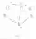
FIG. 1 is a schematic diagram of an exemplary embodiment of a wireless direction system, the direction system including a portable device.
FIG. 2 is a block diagram of the portable device of FIG. 1.
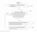
FIG. 3 is a flowchart of an exemplary embodiment of a wireless direction method.
DETAILED DESCRIPTION
Referring to FIGS. 1 and 2, an exemplary embodiment of a wireless direction system includes a global positioning system (GPS), a data server 20, a base station 40, and a portable device 50. The GPS includes a plurality of satellites 10. In this embodiment, the data server 20 stores service information, for example, introductions to areas of the venue utilizing video and audio content. In one embodiment, the portable device 50 may be a mobile phone, a notebook computer, or other kind of portable device.
The portable device 50 includes a GPS receiver 502, a processor 503, and a memory 506 connected to the GPS receiver 502 and the processor 503. The memory 506 includes a comparison module 512 and a service information processing module 513, each of which stores one or more computerized instructions to be executed by the processor 503.
The GPS receiver 502 receives signals output from the plurality of satellites 10 after every predetermined interval, for example, three minutes, and calculates location coordinates of the portable device 50. In one embodiment, the location coordinates of the portable device 50 may include a longitude, a latitude, and an altitude of the portable device 50.
The comparison module 512 logs onto the data server 20 via the base station 40 by wireless internet access, and determines whether service information corresponding to the location coordinates of the portable device 50 is present on the data server 20. The comparison module 512 sends the service information to the service information processing module 513 in response to successful locating of the service information corresponding to the location coordinates of the portable device 50.
The service information processing module 513 receives the service information and provides it to users.
FIG. 3 is a flowchart of an exemplary embodiment of a wireless direction method. The method includes the following steps.
In step S100, the GPS receiver 502 receives signals output from the plurality of satellites 10, and calculates location coordinates of the portable device 50.
In step S102, the comparison module 512 logs onto the data server 20 via the base station 40 by wireless internet access, and determines whether service information corresponding to the location coordinates of the portable device 50 is present on the data server 20. If the service information corresponding to the location coordinates of the portable device 50 is located, step S104 is implemented. If not, step S100 is repeated.
In step S104, the comparison module 512 sends the service information to the service information processing module 513.
In step S106, the service information processing module 513 receives the service information and provides it to users, and the procedure returns to step S100.
It is to be understood, however, that even though numerous characteristics and advantages of the embodiments have been set forth in the foregoing description, together with details of the structure and function of the embodiments, the disclosure is illustrative only, and changes may be made in details, especially in matters of shape, size, and arrangement of parts within the principles of the embodiments to the full extent indicated by the broad general meaning of the terms in which the appended claims are expressed.
Claims
What is claimed is:1. A wireless direction system comprising:
a plurality of satellites;
a data server storing service information;
a base station for mobile communications; and
a portable device comprising a processor, a global positioning system (GPS) receiver to receive signals output from the plurality of satellites after every predetermined interval and calculate location coordinates of the portable device, and a memory connected to the GPS receiver and the processor, the memory comprising a plurality of modules each of which stores one or more computerized instructions to be executed by the processor, wherein the plurality of modules comprises:
a comparison module to log onto the data server via the base station by wireless internet access, determine whether service information corresponding to the location coordinates of the portable device is present on the data server, and output the located service information; and
a service information processing module to receive the service information and provide it to users.
2. The system of claim 1, wherein the portable device is a mobile phone.
3. The system of claim 1, wherein the portable device is a notebook computer.
4. A wireless direction method comprising:
receiving signals output from a plurality of satellites, and calculating location coordinates of a portable device;
logging onto a data server via a base station by a wireless internet access, determining whether service information corresponding to the location coordinates of the portable device is present on the data server, and outputting the located service information; and
receiving the service information and providing the service information to users.
5. The method of claim 4, wherein the portable device is a mobile phone.
6. The method of claim 4, wherein the portable device is a notebook computer.
Images & Drawings included:


Sources:
- United States Patent and Trademark Office - verify current appl. status at the USPTO↗
Similar patent applications:
- » 20230223998
ANTENNA DIRECTION DETERMINING METHOD, WIRELESS COMMUNICATION SYSTEM AND COMMUNICATION DEVICE - » 20060148525
Base station antenna system and method for estimating mobile station direction in wireless communication system - » 20110051678
Channel status determination method and related wireless local area network system and direct link setup method - » 20180317268
Method for direct communication between terminals in wireless communication system and apparatus for method - » 20180317077
Method for direct communication between terminals in wireless communication system and apparatus for method - » 20180332652
Device-to-device direct communication method in wireless communication system and device therefor - » 20130089028
WIRELESS COMMUNICATION SYSTEM AND METHOD USING DIRECTIONAL COMMUNICATION - » 20050070302
Method and system for directing a wireless user to a location for improved communication - » 20110176387
Bi-directional wireless acoustic telemetry methods and systems for communicating data along a pipe - » 20200162140
Systems and methods for maintaining directional wireless links of motile devices
Recent applications in this class:
- » 20250093521 2025-03-20
SYSTEMS AND METHODS OF TRACKING AND PROCESSING DATA OF MOVEABLE ASSETS - » 20250067877 2025-02-27
METHOD AND DEVICE FOR PROCESSING GLOBAL NAVIGATION SATELLITE SYSTEM VALIDITY - » 20250060486 2025-02-20
DEVICE AND METHOD FOR AUTONOMOUS POSITIONING OF VEHICLES - » 20250028057 2025-01-23
SYSTEMS AND METHODS FOR SELECTIVE GLOBAL NAVIGATION SATELLITE SYSTEM (GNSS) NAVIGATION - » 20250028056 2025-01-23
SYSTEMS AND METHODS FOR IDENTIFYING CORRELATED USERS - » 20250004141 2025-01-02
METHOD AND APPARATUS FOR DETECTING AND POSITIONING INSPECTION TARGET, DEVICE, AND STORAGE MEDIUM - » 20240427024 2024-12-26
CORRECTING LOCATION ERRORS USING GEOFENCES - » 20240219576 2024-07-04
GNSS LOCATION DETERMINATION USING A VIRTUAL ANTENNA - » 20230350073 2023-11-02
EDGE AND GENERATIVE AI-BASED SUSTAINABLE GPS NAVIGATED WEARABLE DEVICE FOR BLIND AND VISUALLY IMPAIRED PEOPLE - » 20230333257 2023-10-19
Wireless devices, systems and methods for long range radio frequency location tracking of objects
Recent applications for this Assignee:
- » 20140233961 2014-08-21
Optical communication module including optical-electrical signal converters and optical signal generators - » 20140083669 2014-03-27
HEAT SINK - » 20140063746 2014-03-06
Electronic device with heat dissipation assembly - » 20140061224 2014-03-06
AUTOMATIC VENDING MACHINE - » 20140060914 2014-03-06
Enclosure with shield apparatus - » 20140058727 2014-02-27
MULTIMEDIA RECORDING SYSTEM AND METHOD - » 20140055955 2014-02-27
Fastener - » 20140055322 2014-02-27
DISPLAY SYSTEM AND HEAD-MOUNTED DISPLAY APPARATUS - » 20140054439 2014-02-27
CONTAINER DATA CENTER WITH SUPPORTING APPARATUS - » 20140054311 2014-02-27
AUTOMATIC VENDING MACHINE WITH MOVING MEMBER FOR PRODUCTS