Integrated IoT (Internet of Things) system solution for smart agriculture management
US20180262571A1
2018-09-13
15/451,420
2017-03-07
✅ Patent granted
US 10,728,336 B2
2020-07-28
-
-
Michael C Zarroli
2038-02-06
Abstract:
Currently there is no viable end to end integrated technology solution platform available to increase overall crop yield nor well established communication platform nor infrastructure for agriculture management, logistics, storage, distribution and delivery.
This patent is offering a global solution to this problem where it will provide a consolidated and integrated IoT (internet of things) system platform with AI (artificial intelligence) where data collection, monitoring, control and communication platform are all managed using a single platform.
The utility model relates to the technical field of wireless sensing, specifically an agricultural IoT (Internet of Things) monitoring device based on optical fiber sensing, wherein the device can monitor the temperature, humidity, vibration and other parameters of an agricultural cultivation base. The device is characterized in that the device is provided with a microcontroller, a parameter recorder and the parameter recorder is connected with the sensors. For example: soil temperature sensor and humidity sensors, a soil moisture sensor, a soil conductivity sensor, an air temperature and humidity transducer, a soil salinity sensor, etc.
The upper computer is connected with the parameter recorder and the air temperature and humidity transducer through a communication circuit and using WiFi mesh network, data is transferred to a remote laptop or smartphone. Data is stored in cloud for predictive data analysis with AI and real time data analysis which automatically or remotely trigger proactive & preventive actions, thereby increasing crop yield, reduce water consumption and food waste during storage and streamlined logistics of food distribution to the market.
User has the option to control how often data is generated and the relevant information. User can set automatic trigger to manage proactive and preventive action on the control system. User can also remotely access and manual set future action either via smart phone or tablet based on actionable output from predictive data analytics.
This single integrated IoT system platform is providing end to end solution that is reliable, suitable and effective for agriculture, greenhouse, lawn/yard and garden (both indoor and outdoor) applications.
This integrated IoT system is also applicable in various sector such as: Geotechnical soil testing, Oil and Gas Industries (drilling, flow control, oil pipeline management, oil refineries management), Air quality and Waste management, Semiconductor fabrication and Chemical Plant management, Oceanography and atmospheric/environmental science data monitoring for global warming, Fisheries/Aquaculture management, Data center and Cloud device management, Enterprise sustainability management, Inventory, logistics and Supply Chain management and Infrastructure (road, bridges, tunnels, dams, airports, electric grid) management.
This integrated IoT system is also applicable to detect earthquake and tsunami where the sensor devices are embedded with multiple sensors installed in the buildings, bridges, bus stops, underground pits, lakes, roads, nearby mountains etc, different data can be captured and analyzed for earthquake predictability and structural integrity of the buildings to prevent collapse during earthquake, a smart alert is sent to mobile phones to authorities to minimize death and destruction.
Assignee:
- Sabrina Akhtar 1 🇺🇸 Palo Alto, CA, United States
Applicant:
Interested in similar patents?
Get notified when new applications in this technology area are published.
Classification:
B64C2201/12 » CPC further
Unmanned aerial vehicles; Equipment therefor adapted for particular use
G06Q50/00 IPC
Systems or methods specially adapted for specific business sectors, e.g. utilities or tourism
G06Q10/08 IPC
Administration; Management Logistics, e.g. warehousing, loading, distribution or shipping; Inventory or stock management, e.g. order filling, procurement or balancing against orders
G06Q10/06 IPC
Administration; Management Resources, workflows, human or project management, e.g. organising, planning, scheduling or allocating time, human or machine resources; Enterprise planning; Organisational models
A01G25/16 » CPC further
Watering gardens, fields, sports grounds or the like Control of watering
B64C2201/123 » CPC further
Unmanned aerial vehicles; Equipment therefor adapted for particular use for imaging, or topography
H04W4/02 » CPC further
Services specially adapted for wireless communication networks; Facilities therefor Services making use of location information
G06Q50/28 » CPC further
Systems or methods specially adapted for specific business sectors, e.g. utilities or tourism Logistics, e.g. warehousing, loading, distribution or shipping
G06Q30/02 IPC
Commerce, e.g. shopping or e-commerce Marketing, e.g. market research and analysis, surveying, promotions, advertising, buyer profiling, customer management or rewards; Price estimation or determination
H04W4/70 » CPC further
Services specially adapted for wireless communication networks; Facilities therefor Services for machine-to-machine communication [M2M] or machine type communication [MTC]
H04W84/18 » CPC further
Network topologies Self-organising networks, e.g. ad-hoc networks or sensor networks
B64C39/024 » CPC further
Aircraft not otherwise provided for characterised by special use of the remote controlled vehicle type, i.e. RPV
A01G25/167 » CPC further
Watering gardens, fields, sports grounds or the like; Control of watering Control by humidity of the soil itself or of devices simulating soil or of the atmosphere; Soil humidity sensors
G08B21/10 » CPC further
Alarms responsive to a single specified undesired or abnormal condition and not otherwise provided for; Alarms for ensuring the safety of persons responsive to calamitous events, e.g. tornados or earthquakes
H04M1/725 IPC
Substation equipment, e.g. for use by subscribers; Mobile telephones; Cordless telephones, i.e. devices for establishing wireless links to base stations without route selection Cordless telephones
B64C39/02 IPC
Aircraft not otherwise provided for characterised by special use
B64C31/06 » CPC further
Aircraft intended to be sustained without power plant; Powered hang-glider-type aircraft; Microlight-type aircraft Kites
B64D47/08 » CPC further
Equipment not otherwise provided for Arrangements of cameras
H04L67/12 » CPC main
Network arrangements or protocols for supporting network services or applications; Protocols specially adapted for proprietary or special-purpose networking environments, e.g. medical networks, sensor networks, networks in vehicles or remote metering networks
G05B13/0275 » CPC further
Adaptive control systems, i.e. systems automatically adjusting themselves to have a performance which is optimum according to some preassigned criterion electric the criterion being a learning criterion using fuzzy logic only
G06Q10/06313 » CPC further
Administration; Management; Resources, workflows, human or project management, e.g. organising, planning, scheduling or allocating time, human or machine resources; Enterprise planning; Organisational models; Operations research or analysis; Resource planning, allocation or scheduling for a business operation Resource planning in a project environment
G06Q10/087 » CPC further
Administration; Management; Logistics, e.g. warehousing, loading, distribution or shipping; Inventory or stock management, e.g. order filling, procurement or balancing against orders Inventory or stock management, e.g. order filling, procurement, balancing against orders
G06Q30/0202 » CPC further
Commerce, e.g. shopping or e-commerce; Marketing, e.g. market research and analysis, surveying, promotions, advertising, buyer profiling, customer management or rewards; Price estimation or determination Market predictions or demand forecasting
G06Q50/01 » CPC further
Systems or methods specially adapted for specific business sectors, e.g. utilities or tourism Social networking
H04L67/025 » CPC further
Network arrangements or protocols for supporting network services or applications; Protocols based on web technology, e.g. hypertext transfer protocol [HTTP] for remote control or remote monitoring of applications
G05B13/02 IPC
Adaptive control systems, i.e. systems automatically adjusting themselves to have a performance which is optimum according to some preassigned criterion electric
G06F16/29 » CPC further
Information retrieval; Database structures therefor; File system structures therefor of structured data, e.g. relational data Geographical information databases
H04W4/38 » CPC further
Services specially adapted for wireless communication networks; Facilities therefor; Services specially adapted for particular environments, situations or purposes for collecting sensor information
Description
BACKGROUND OF THE INVENTION
The present invention is directed to an integrated IoT (Internet of Things) system for Smart Agriculture management increasing crop yield, optimize food storage, distribution and delivery using IoT and Artificial Intelligence in its communication and supply chain infrastructure
DESCRIPTION OF THE RELATED ART
Currently there is no viable platform infrastructure of consolidated resources for growers to collect personalized agriculture monitoring for strategic crops growth, manage soil condition, pesticide control, fertilizer selection, crop selection, etc. There is no consolidated system to increase overall crop yield, nor well established communication platform to connect the growers to the market, nor any viable infrastructure for optimized management of food storage logistics and food distribution and food delivery to the marketplace and to the consumers.
SUMMARY OF THE INVENTION
In one embodiment of the present invention, this single system platform provides a solution to collect and monitor agriculture data in real time using IoT (Internet of Things) platform integrated with Artificial Intelligence to provide predictive data analytics to proactively trigger preventive actions automatically or remotely.
The other embodiment is to provide communication infrastructure system with social media platform for connecting growers to the marketplace and optimizing logistics of food storage and distribution and food delivery to the market. This integrated IoT system will increase crop yield, reduce water consumption, reduce waste during food storage and distribution and food security.
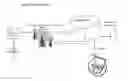
BRIEF DESCRIPTION OF THE DRAWINGS (PLEASE SEE ENCLOSED DRAWING FILE)
FIG. 1 represents flowchart of how the data is collected from the field
FIG. 2 represents flowchart on how data is monitored
FIG. 3 represents flowchart of how the control system works
FIG. 4 provides communication infrastructure platform flow
DETAILED DESCRIPTION
Field System
The lifeline unit (see FIG. 1) comes with a microcontroller connected to sensor network that comprises of soil moisture probe, soil temperature probe, soil pH & salinity probe) embedded into the soil. Soil data is collected by soil moisture sensor which is radial probe with 2 electrodes, one down the center and one wraps around it. It's a resistance device that is embedded into the soil which comes to equilibrium with the soil moisture.
It is then measured resistance in the wires that's comes with the sensor indicates the soil moisture level or water content of the soil. The data from the sensor probe is sent to the attached microcontroller thru the wires that comes with the sensor.
The leaf wetness sensor measure LWD (leaf wetness duration) placed on the leaves at various location of the field also attached to the microcontroller.
The sensors are embedded at different depth of the soil and surrounding area connected to the microcontroller with WiFi module. The microcontroller with sensor probe is placed strategically to create a WiFi mesh network for optimum accurate data collection through WiFi over large distance. The sensors are marked using GPS. This allows ease of transfer of soil moisture and temperature data to the central computer at the base station or on the user smartphone for remote monitoring. Please refer to FIG. 1 flowchart.
The unit where the microcontroller is attached, it is extended upward to collect weather data, it is equipped with weather probe that collects humidity, temperature, wind speed, wind direction & rain fall. This unit also has built in artificial light system (grow light, electromagnetic spectrum to increase photo synthesis) that provides added illumination during rainy or cloudy days and after sunset. This unit is powered by solar panels attached to the top along with battery to give it 3.3V electricity.
The drip and sprayer system is strategically placed on the ground based on moisture data and crop type. The sprayer system can also spray fertilizer.
Use large Kite or UAV drone system with camera attached to remotely collect image from the field in real time to check the state of the crop over large area.
Monitor System
Using Microcontroller board and mesh WiFi data network systems (please see FIG. 2) data is collected from the lifeline unit is then transferred over to the central microcontroller board and WiFi shield at the base station or through cellular network, GPS on users smartphone.
The sensor module data is stored over cloud and data analytics with artificial intelligence software module is performed to visualize soil moisture data and soil moisture trend, soil temperature, soil pH (amount of nitrogen, salinity etc.) data to determine soil condition, leaf moisture data to determine leaf condition, the amount of dew duration that correlates to disease detection and soil moisture prediction based on historic weather data and moisture data.
Illumination data gathered is to determine the level of intensity used, weather data (air temp, humidity, wind speed, wind direction, rain fall, etc.) The kite (please refer to FIG. 2 of the drawing file) uploads image data automatically to cloud for visual analysis. The graphical pattern and trend analysis is done using AI (artificial intelligence) for predictive analytics to send trigger action message to the control system.
User has the option to auto send alert to their smart phone. User can login to their agriculture monitoring platform from anywhere in the world via the Internet.
Control System
The control system is comprised of drip and sprayer system. The artificial intelligence modeling of the monitored data determines prescriptive action and use of fuzzy logic input parameters to trigger action to the drip and sprayer system.
The drip and sprayer system helps in controlled irrigation and fertilization process
The triggering mechanism can be programmed to turn on and off the illumination unit based on sunlight condition (data gathered from weather system) with option for adjusting the light intensity.
Users can issue command from their smartphone user interface to trigger flight to the kite or UAV system. Also, user has option to harness the power of satellite images, all of these options are given on the menu driven user application interface.
With leaf wetness data monitoring which gives information on disease detection will trigger amount of pesticide to be used by the sprayer assembly.
With the weather data and soil data monitoring, users are alerted optimum time to seed and varieties of seedlings recommendations for early seeding. It will also connect users with the companies providing seeds for planting and setup automatic seed order should users set it up accordingly.
Communication System
The communication system is comprised of Crop Selection & Mapping data, Market Connection, Seed Connection and Social Media Connection
Crop Selection & Mapping data
User use the software which is equipped with options for personalization based on their location and soil condition and historical soil data that will provide recommendations on crop selection. This crop selection algorithm will be referenced to the central database from US agriculture department for the crop list based on the geographical region, climate and soil map data. It will provide suggestions on which crop to grow when, how to grow, etc.
Market Connection
This platform will connect the growers to the market and consumers to determine which crop are in demand based on predictive analytics and the market value for the crop.
Seed Connection
This system will connect growers to the breeders to get farmers input in better seed breeding and providing growers with high quality seed.
Social Media Connection
The growers can also connect to neighboring growers to exchange information, make deals on combined volume production for market supply, get advice on farming and a platform for flow of ease of information sharing.
Food Storage, Logistics, Distribution and Delivery
This platform provides logistics for farm produce storage and distribution to the market using Artificial Intelligence and IoT sensors and GPS (Global Positioning System) to track the flow real time. Farmers, distributors, market and consumers can monitor the location of farm produce delivery by using logistics tracking at any given moment using the user application interface.
Claims
a) An integrated IoT (Internet of Things) connected system comprising of hardware and software with artificial intelligence, this system uses wireless sensing capability to collect and monitor real time all agriculture, greenhouse, garden & lawn output such as: crop climate & weather, field image data using kite, satellite or UAV (unmanned aerial vehicle) etc. on remote computers, laptop or handheld devices such as tablet or smartphone wherein data can be accessed both onsite or remotely
b) The integrated IoT system in claim (a) further characterized in that, the predictive analytics are performed using collected real time streaming data with artificial intelligence to model the data that is trained and hence generate the predictive data to automatically or remotely trigger proactive and preventive actions on the field. This automatic proactive and preventive action leads to higher yield, energy and cost savings, reduce water consumption and food waste which are not captured in the prior art.
c) The integrated IoT system in claim (b) comprised of added feature which is providing communication infrastructure and social media networking platform for connecting user to the local and overseas market and resources and is further comprised of optimizing logistics of food storage, food tracking and distribution and food delivery to the marketplace and consumers
d) The said integrated IoT system in claim (a), (b) and (c) cover diverse applications. The said IoT system is applicable for Geotechnical soil survey, geotechnical investigations, minerals exploration, geotechnical drilling including various soil testing to remotely provide actionable data that prompt user to take action
e) The said integrated IoT system are also applicable for air quality measurement data collection and hazardous waste material detection to provide user remote monitoring capability and actionable data output
f) The said integrated IoT system platform is further applicable for hydrocarbon detection in soil and sea water. The said integrated IoT system is applicable in oil drilling, monitoring pipelines and oil refinery management to provide remote monitoring with actionable result with a platform of integrated communications
g) The said integrated IoT system platform is applicable in Fisheries and Aquaculture management
h) The said integrated IoT system platform is usable in Semiconductor Fabrication Plant and Chemical Plant to monitor and provide actionable data to reduce equipment downtime and improve productivity
i) The said integrated IoT system platform is usable in Oceanography, atmospheric and environmental monitoring for global warming to provide useful and actionable data
j) The said integrated IoT system platform is also applicable to detect earthquake and tsunami, provide predictable analytics, structural integrity of the buildings and bridges, send smart alert to mobile phones to minimize death and destruction
k) Further to item (j) above, the said integrated IoT system platform also covers monitoring old infrastructure such as bridges, electric grid, dams, roads, tunnels, airports to determine structural integrity and maintenance ahead of time due to integration of predictive analytics using artificial intelligence with IoT
l) Further to item (h) above, the said integrated IoT system platform covers building and factory management for sustainability to reduce carbon footprint and tracking green house gas emission
m) The said integrated IoT system platform covers hardware device (bluetooth low energy beacon or sensors) communicating with user smartphone applications to give user location specific information (example use cases are: museums, airports, ski resorts, hotels & resorts, theme parks, zoo, farms, greenhouses, outdoor parks, conference & events)
n) Further to item(c) above, the said integrated IoT system platform covers inventory management and inventory tracking, data center management & asset maintenance
o) Further to item(c) above, the said integrated IoT system platform covers logistics and supply chain management
Images & Drawings included:


Sources:
- United States Patent and Trademark Office - verify current appl. status at the USPTO↗
Recent applications in this class:
- » 20250294075 2025-09-18
DEVICES AND METHODS FOR PROVISION OF RESOURCE REPRESENTATIONS - » 20250294074 2025-09-18
FIELD DEVICE AND METHOD FOR CONTROLLING A NEAR FIELD COMMUNICATION VIA A NEAR FIELD COMMUNICATION SYSTEM OF A FIELD DEVICE - » 20250286929 2025-09-11
METHODS, SYSTEMS, AND STORAGE MEDIA FOR INFORMATION MANAGEMENT OF INDUSTRIAL INTERNET OF THINGS (IIOT) BASED ON CLOUD PLATFORMS - » 20250286928 2025-09-11
SYSTEM AND METHOD OF MANAGING OPERATION OF WIRELESS SOCKETS - » 20250286927 2025-09-11
TELEMETRY-BASED ANOMALY DETECTION - » 20250274519 2025-08-28
SYSTEM AND METHOD FOR TRANSMITTING DATA AND ORDERING ASYNCHRONOUS DATA - » 20250274518 2025-08-28
SYSTEM AND METHOD FOR SERVER BASED CONTROL - » 20250274517 2025-08-28
SYSTEM AND METHOD FOR SERVER BASED CONTROL - » 20250274516 2025-08-28
TRAIN DATA TRANSMISSION SYSTEM AND METHOD, APPARATUS, AND MEDIUM - » 20250274515 2025-08-28
SYSTEMS AND METHODS FOR MANAGING AN INDUSTRIAL DIGITAL TWIN AND CONTROLLING AN INDUSTRIAL DEVICE USING AN EDGE DEVICE